
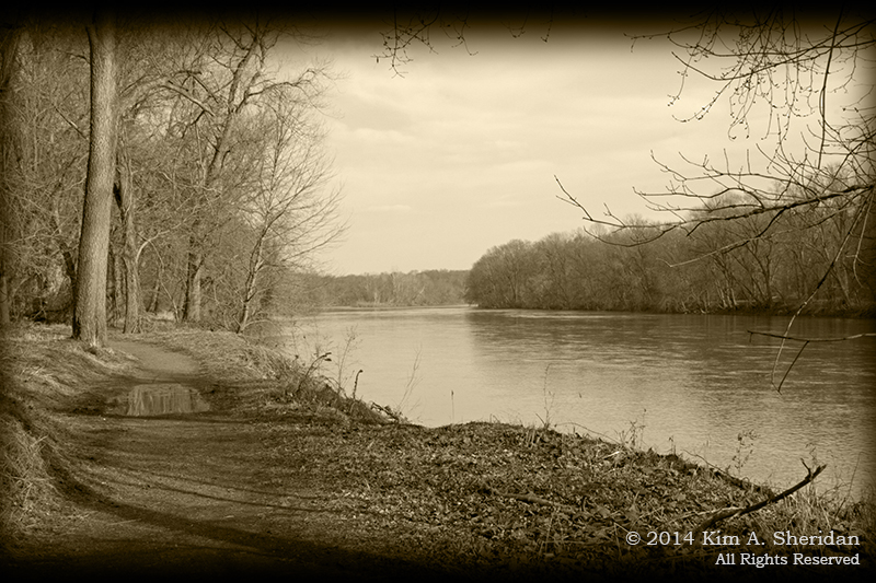
 We dipped our paddles into the rippled waters of the Susquehanna River, and paddled back in time. Continue reading
Tag Archives: History
The Twin Lights of Navesink
 Seafaring is a dangerous business. Be they sail or steam, passenger or cargo, many ships have gone down along the Atlantic Coast over the centuries. Powerful storms and strong, tricky currents make navigating harbors a challenge that in darkness is nigh unto impossible.
Which is why man made lighthouses.
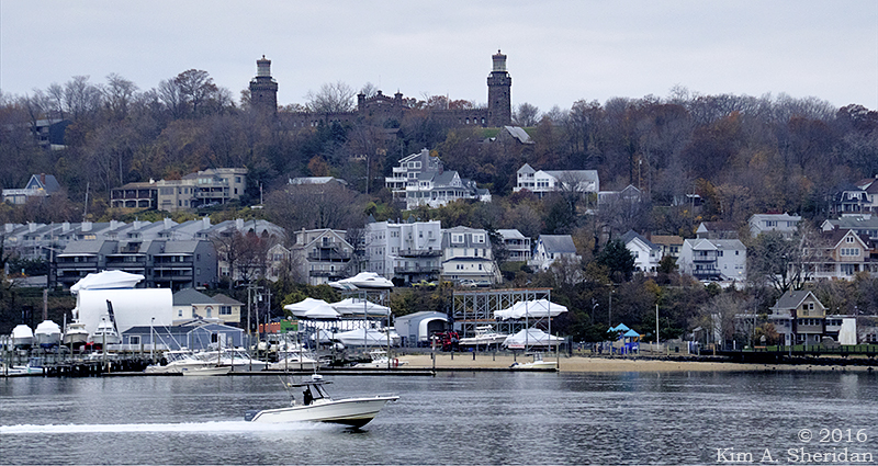
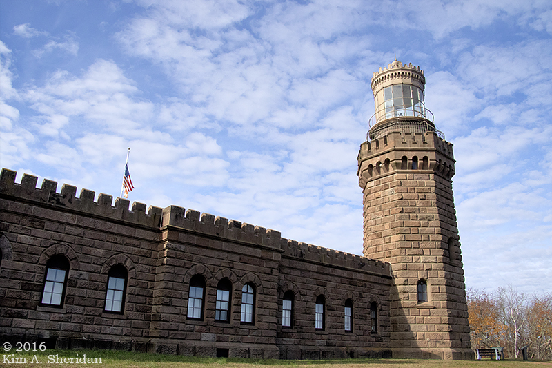
Towers topped with bright lights visible for miles dot the coasts and Great Lakes of North America. Sandy Hook Light has guarded the southern entrance to New York Harbor since before the American Revolution. In 1828, help arrived: the Navesink Highlands Light Station, otherwise known as the Twin Lights.
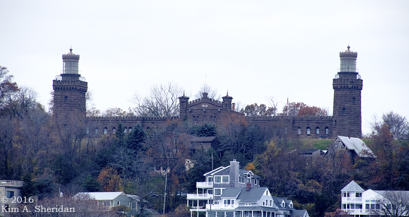 The name says it all – there are TWO lights to this light station. Rebuilt of local brownstone in 1862, the towers are linked by keeper’s quarters. They stand 64 feet high atop a 200’ hill overlooking the Shrewsbury River.
 The two towers are different shapes, the North being octagonal and the South square.
At night, the two beacons, one fixed and one flashing, were easy to distinguish from the light at Sandy Hook.
They were also easy to see. The Twin Lights were the first in America to use the revolutionary Fresnel lens design, when two of these beehive shaped lights were installed in 1841.
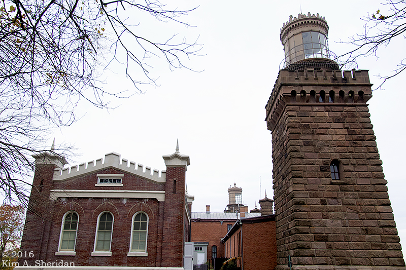 The South Tower’s beehive light was replaced in 1898 with an electric-arc bivalve lens. This light could be seen 22 miles out to sea, the brightest light in the U.S. at the time. It was so bright the North Tower light was taken out of service.
 In 1941 Navesink Light Station was decommissioned and extinguished.
 The 9’ bivalve lens needed its own generator to power it. Today that lens is on display in the Electric Power Station building.
 Close up of the bivalve light.
 The front of the building that connects the two lights. The battlements along the roof and the towers at each end give the Twin Lights a fortress-like feel.
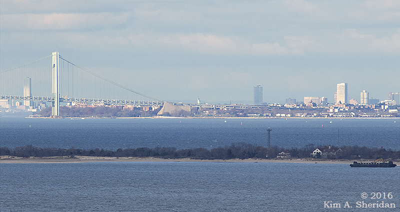
 The cannon adds to the ambience. On clear days the New York skyline is visible from the Twin Lights site. So is the Statue of Liberty, according to Robb.
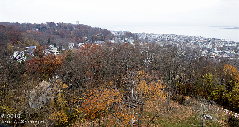 The view from the top of the North Tower.
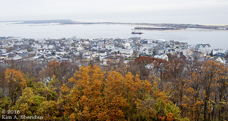
 The South Tower and the Shrewsbury River.
 Looking across to Sandy Hook. The first demonstration of Marconi’s wireless telegraph took place here in 1899, at the America’s Cup yacht races off Sandy Hook.
 The North Tower.
Now a National Historic Landmark, this life-saving light station reminds us of the years it stood watch over the harbor, its beacons a comfort to all who passed.
 The Twin Lights of Navesink.
Sandy Hook to the Rescue
HOEK (Dutch): Corner, angle; spit of land.
The long spit of land known as Sandy Hook, comprised of beaches, dunes and maritime forest, is a recreational wonderland. It serves a higher purpose, though. For centuries the spit has guarded the entrance to New York Harbor. The peninsula, owned by the federal government since 1814, has long been essential to the safety of mariners and the defense of New York. There’s a lot of history resting on the shifting sands of Sandy Hook!
 New York Harbor is one of the busiest in the nation. Seafaring is always treacherous, and many ships foundered off the Jersey Coast. In the 1870s, the U. S. Life-Saving Service was established, to watch the coast and rescue stranded seamen. Life-saving stations like this one were built along the coast. Spermaceti Cove Station No. 2, built in 1894, housed a six man crew of “surfmen” and their rescue equipment.
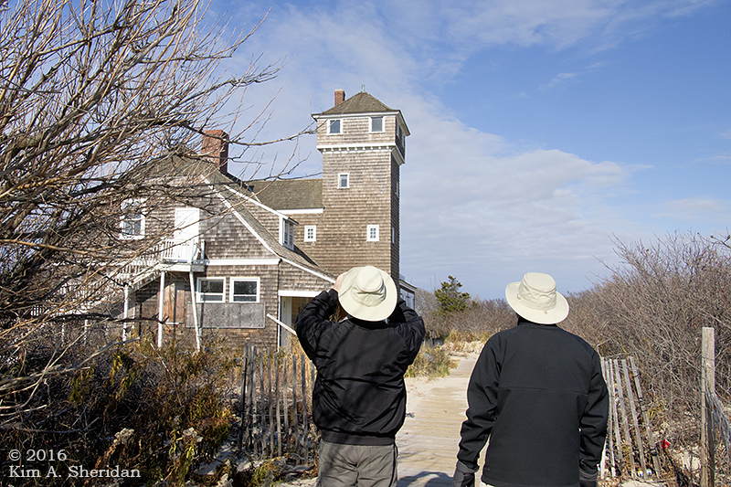 The Spermaceti Cove station was used by the Life-Saving Service and subsequently by the U.S. Coast Guard until the 1940s. It has served as the Visitor Center for the Sandy Hook unit of Gateway National Recreation Area since the 1970s. Damaged in Hurricane Sandy, it’s now closed, to our deep disappointment. We could only admire the old girl from the outside.
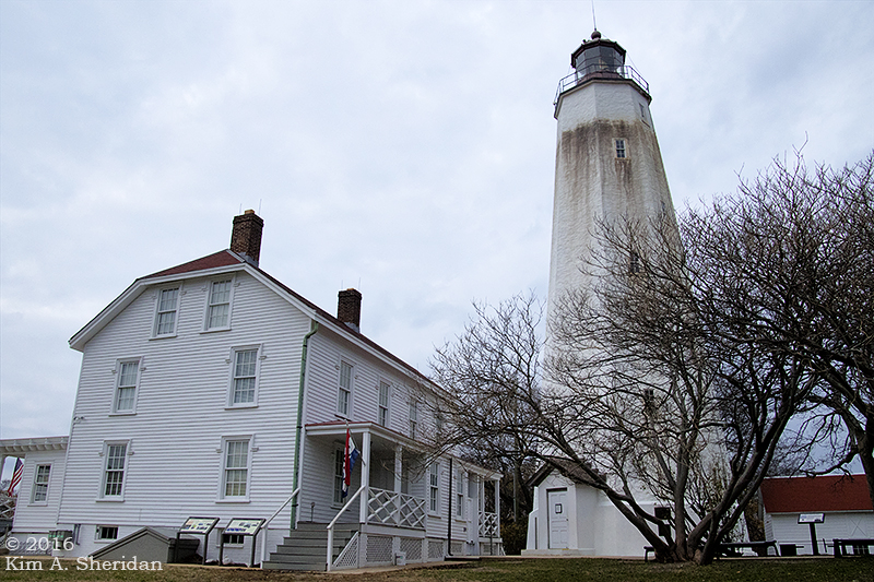
Also guarding the harbor is the Sandy Hook Light.
 First lit in 1764, it was captured by the British in 1776, withstood an American attack, and was held until the end of the Revolution.
 The Lighthouse Keeper’s Quarters now standing on the site was built in 1883. It also saw life as a U.S. Life-Saving Station.
Sandy Hook Light is still in operation 24 hours a day, using an automated, fixed 3rd-order Fresnel lens. When it was built in 1764, water lapped the shore just 500 feet away. The light now stands a mile and a half from the tip of Sandy Hook.
 We took advantage of a chance to climb the 103’ tower. Along the way, deep set windows gave peek-a-boo views of Fort Hancock below.
Sandy Hook’s location at the mouth of New York harbor made it the perfect place to build a fort to defend the harbor and New York City.
A wooden fort called Fort Gates served during the War of 1812. Fort Hancock replaced it in the late 1800s.
 A view of Fort Hancock from the lighthouse. This is Officers Row, a group of yellow brick residences. Enlisted men lived in barracks and a small village of supporting buildings sprouted up over the years. The population of Fort Hancock peaked during World War II at nearly 12,000 military personnel.
Much of the fort’s defenses centered on concrete gun batteries using the most powerful cannons of the day. After WWII, the fort’s mission shifted to an array of Nike air defense missiles. At the end of 1974, Fort Hancock was officially decommissioned. It now is part of Gateway National Recreation Area.
 Fort Hancock’s Nine-gun Battery.
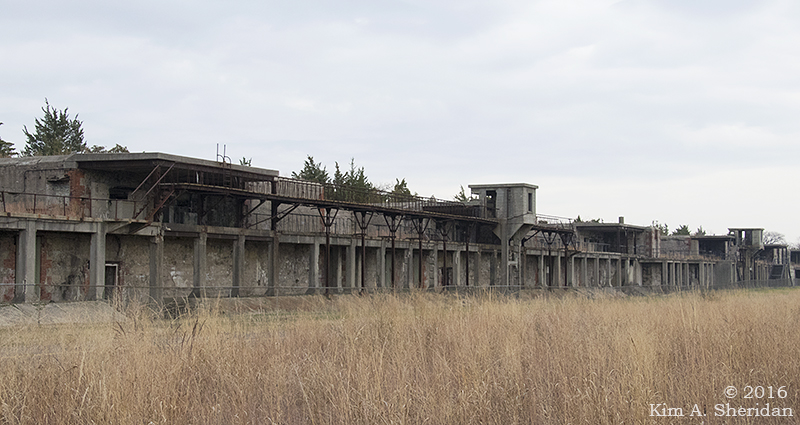 These old gun batteries were quite picturesque, in a moody sort of way.
 Battery Peck.
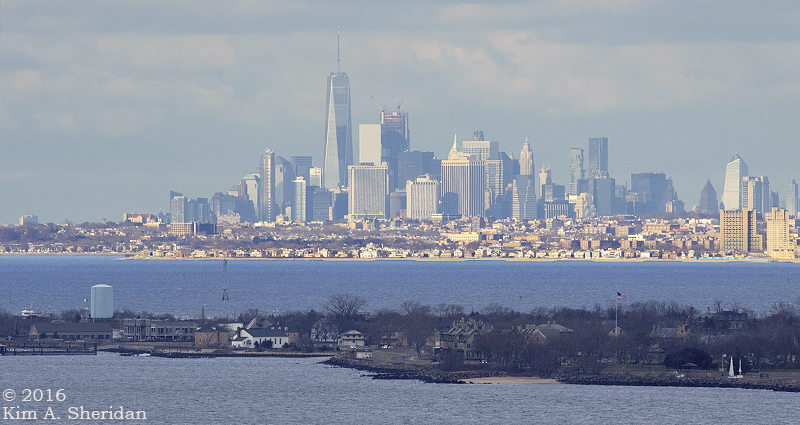 Near Sandy Hook, in Atlantic Highlands, is Mount Mitchill Scenic Overlook. Perched at 266’, the highest natural elevation on the Atlantic Coastal Plain, it offers sweeping vistas of Sandy Hook, Raritan Bay and New York City. You get a feel for the strategic importance of Sandy Hook to the defense of New York and the safety of seamen traveling into the harbor.
Throughout the weekend, from every high point and lighthouse, we searched for the Statue of Liberty. Throughout the weekend, from every high point and lighthouse, Robb claimed to see her.
Atop the Sandy Hook Light, Robb declared that he could see the Statue. Again,
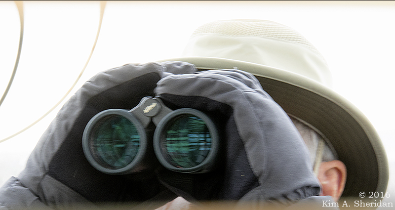 Don was skeptical. She never seemed to be where Robb said she was.
After two days of following Robb’s guidance, to no avail, I sought the aid of other visitors to Mount Mitchill. Within minutes, thanks to them, I had found what I was looking for.
 At last! Lady Liberty! Let’s zoom in…
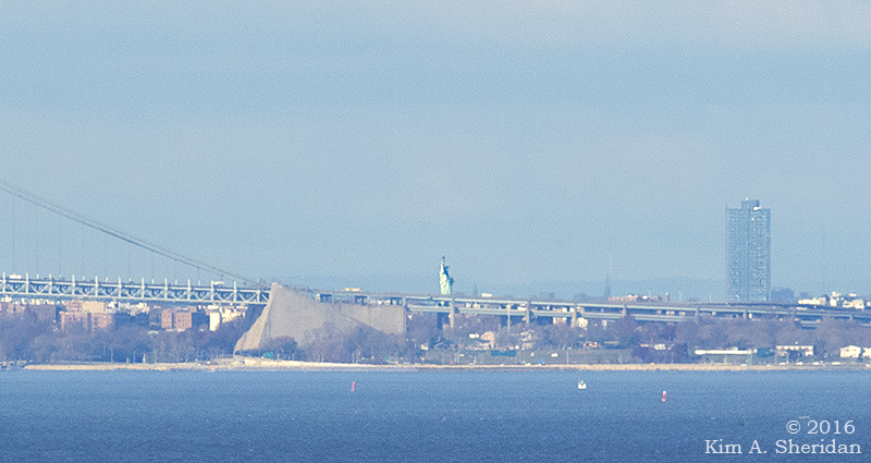 There she stands, the symbol of freedom, the symbol of welcome to all who come to our beautiful land.
And guarding her flanks, Sandy Hook, ever vigilant.
The Hunt for Doan’s Cave
 BUCKS COUNTY, 1781… A band of ruthless outlaws known as the Doan Gang rob the Bucks County Treasury in Newtown of 1,300 pounds sterling. It was one of many crimes committed by five Quaker brothers and their cousin. Loyal to the British crown, the Doans made a career out of robbing Colonial tax collectors, stealing horses to sell to the British and even spying for the Redcoats. According to numerous legends, the gang amassed a small fortune, and stashed the loot in one or more caves in the hills of Bucks County.
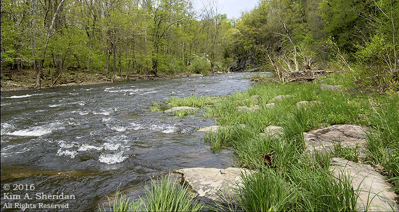
BUCKS COUNTY, 2016… A band of intrepid explorers go in search of the Doan Gang spoils. The most well-known of the caves is rumored to be along the banks of Tohickon creek. The only clue to its whereabouts is a small dot on a Bucks County map labeled “Doan’s Cave.”
Well, that and a few Internet photos and postings that serve as a signpost to the impossible-to-miss cave.
Conveniently, there’s a State Park, and a trail.
 The latter was a scenic walk along the creek, with a couple of tricky crossings over steep banked runs that fazed our daring adventurers not one whit. Soon enough, rock outcroppings began to appear on the hillside above them. Just the place for a cave.
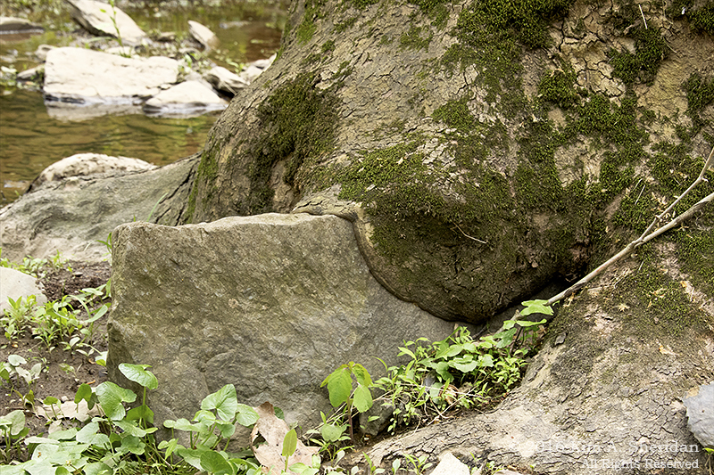
 The first such outcropping held no cave, but sported an impressive covering of lichens and moss. It was also an irresistible place for some camera-mugging by the irrepressible Major Robb, not seen here.
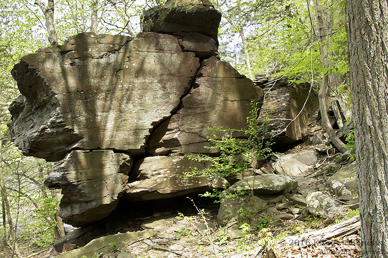 The next rocky formation had been cleft nearly in two on one end. Two trails split around it. Which to follow?
Left, and down, to the base of the rocks.
 Behold! Doan’s Cave!
 Obviously our heroes were far from the first to seek their fortune here. Someone had even been kind enough to put down cushy floor boards for their fellow treasure hunters.
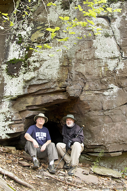 Major Robb and Major Don at the mouth of Doan’s Cave…
 … And standing stalwart and resolute amongst the boulders. Why does Major Don look so sad? Clearly the disappointment of finding no Doan Treasure in Doan’s Cave weighs heavily upon his mind.
 Being lighter of heart, the other members of the expedition make a foray to the shores of Tohickon Creek.
 Our fearless fortune-hunters, finding no gold or silver, went off in search of other types of treasure. This they found in spades on the far side of the creek. The footpath led over a covered bridge, which was in fact not covered at all. A faux bridge.
The creek-side path yielded a bumper crop of wildflowers. This was a source of boundless amusement for Major Robb, who busied himself attempting to identify each one. Conveniently for the rest of the expeditionary party, it got him out of their hair.
 Spring beauty.
 Wild Blue Phlox.
 Dame’s Violet.
 A violet, unnamed, but no less admired.
 Whilst Major Robb was so occupied, the others found their way across a dry gully onto an island of cobble and pebbles. Here a tree was actively swallowing a large rock. In another hundred years, it might well succeed in digesting this stony meal.
 Corporal Kim was suddenly startled by the sight of a large snake at her feet, slithering away from her with all due haste. Seems the plucky lass had unwittingly trod upon its tail. Upon reaching the water’s edge, it forgot its annoyance and fear, and posed quietly for a series of photographs.
 Northern Water Snake.
 Tired, hungry, and quite bereft of treasure of any monetary value, our bold band of explorers bid farewell to Tohickon Creek. Quite content were they with the joys of a day well-spent amidst the natural splendors of Bucks County. Whatever secrets Tohickon Creek yet harbors, she guards them well.
Cades Cove
 Great Smoky Mountains National Park spans more than 800 square miles across two states, Tennessee and North Carolina. With only 5 1/2 days to explore the Park, where do you start?
 For many visitors, including my friend Don and me, you start at Cades Cove. Scenery, wildlife and history – Cades Cove has it all, in one 11-mile driving loop. That’s where we spent our first full day at the Park.
We arrived at the Cove early on a nice morning with blue skies. It would be the last rain-free day we had for a week.
 A “cove”, by the way, is Smoky Mountain parlance for a flat valley between mountain ridges. At Cades Cove, the overlying rock has eroded to expose a valley of limestone. Meadow grasses and plants thrive on limestone soil.
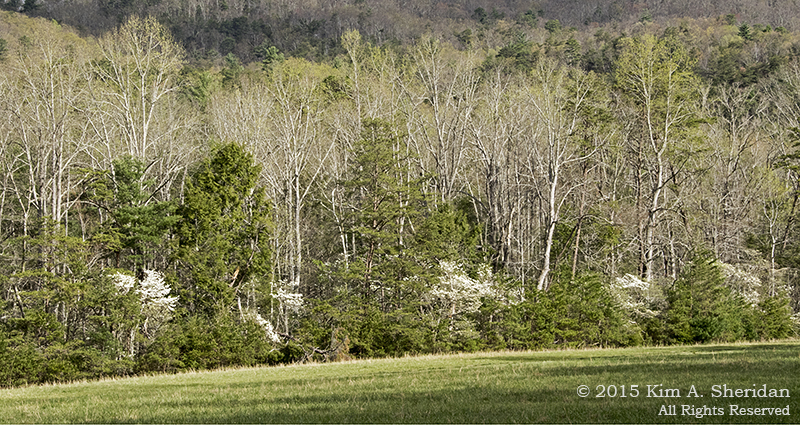
 While some of Cades Cove is wooded, much of it is open, making for some great views of the mountains beyond. In the five hours we spent there, I never got tired of those mountains. Click for the full effect.
There was a lot more to see than just mountains and meadows though. Wildflowers abound, and we saw some interesting wildlife. We also got a real sense of the history of the place.
 Cades Cove was first used by the native Cherokee who hunted deer, elk, bison and bears. The first white settler arrived in this idyllic place before 1820, finding fertile soil and abundant game. A self-sufficient community flourished here for generations, with grist mills, blacksmiths, distillers, stores, churches and schools.
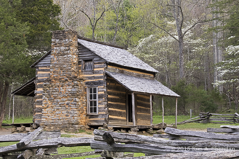
Since the establishment of Great Smoky Mountains National Park in 1934, the area has been maintained as an historic district. Some of the original buildings are still in place, and we stopped to explore them as we drove the loop road. The cabin above was the home of John Oliver, the one of the first settlers of Cades Cove. It’s a simple one-room log cabin, with doors on three sides and a loft above.
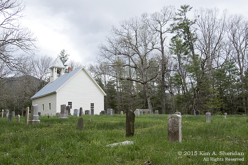 The people of the cove were religious folk. We came to three churches in succession, two Baptist and one Methodist. The Baptists argued over missionary activities and split into two churches; the Methodists argued over Civil War loyalties, and likewise split, although Hopewell Methodist Church no longer stands.
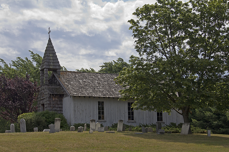
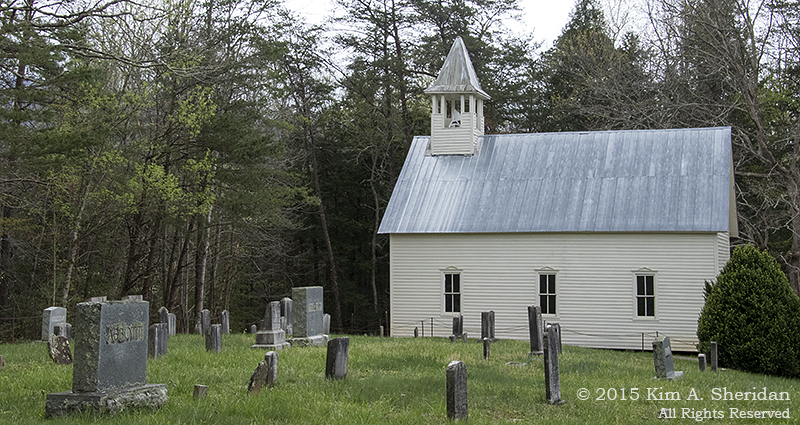 All three churches are spare white frame buildings with a bell tower on top. Inside are rows of pews, and a pulpit. Outside each church is a graveyard, which gave Don and me a change to indulge our interest reading old tombstones. Here Olivers, Tiptons, Shieldses and Cables abound. Many young children were buried in these graves, some too young to even have names. Life could be harsh in Cades Cove.
 The Cable Mill area is a complex of historic buildings. This is a cantilever barn, a typical type of construction in the cove.
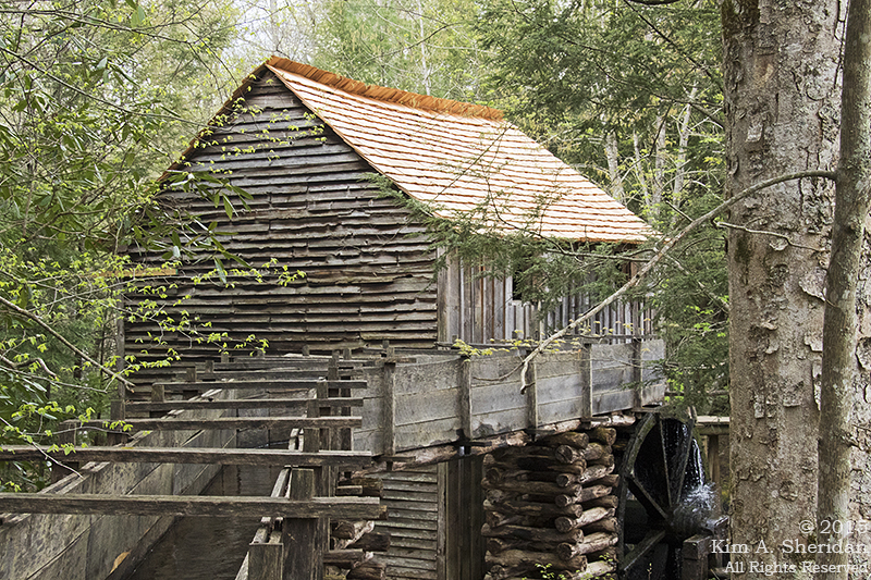 John Cable built and operated a grist mill in 1870. Its large mill wheel and mill race are still functional. Inside, you can see corn being ground and even purchase a small bag of flour.
 After circling the cove, we decided to take the adventurous route home. We drove Rich Mountain Rd, a one-way gravel road that runs up to the top of Rich Mountain, then descends out of the Park into Tuckaleechee Cove. It was a lot of fun winding around the endless twists and turns. Mother Nature’s roller coaster!
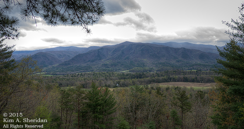 Along the road was an overlook with a fantastic view of Cades Cove and one of the churches. Click to see full size and find the church.
 Here’s one of many switchbacks on the descent. I had to learn how to use low gear on my car’s automatic transmission for this trip!
 History, dramatic scenery, wildlife – yes, Cades Cove has it all.
Wait, what about that wildlife?
That, my friends is a tale for another day.

The Golden Cave
 What more likely place to go hunting for gold than in the heart of the city?
My merry band of adventurers caught wind of an abandoned mine deep in the wilds of the Wissahickon Valley, and quickly signed up for a tour. We set off one day for an easy stroll down Forbidden Drive where it borders cool, green and leafy Wissahickon Creek.
 There was no shortage of flowers and greenery to admire along the way.
Further along, a staircase led down the embankment to a small dam in the creek.
One of our group is a talented professional photographer who is generous with his photographic wisdom, and I soak it all up like a sponge.
At the dam, Ned gave me a homework assignment: photograph the water flowing over the wall at different shutter speeds.
 I know which one I like better – how about you? (Click to see larger image.)
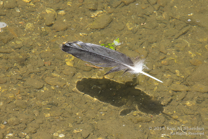 When he wasn’t looking, I forsook my homework and took a photo of a feather drifting lazily down the creek.
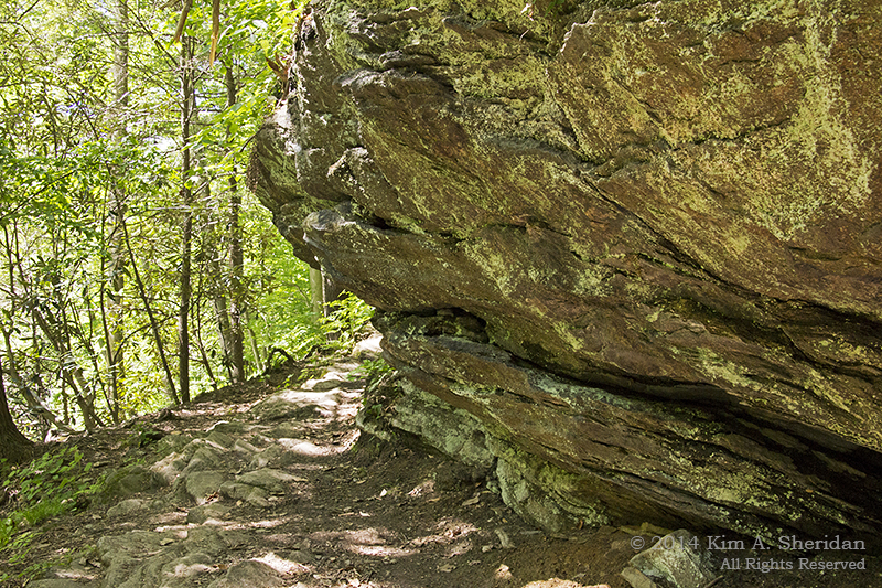
 From a side trail, we got our first glimpse of the gold mine. This outcropping hides a small cave near its base that once was home to a mining operation, way back when in the 1760s.
The Roxborough Mining Company, consisting of a handful of German immigrants, excavated this manmade cave with hand drills and black powder. According to legend they were searching for gold, but having found none, soon abandoned the endeavor.
 Another legend claims this cave was a hidden storehouse of grain during Revolutionary days. Today it holds only tourists like us. Though the cave goes back some distance, the roof is low; here you can see the entrance is half a Robb high.
 An old stone bridge carried us across the creek. A casual amble for us no longer; the trail was much more challenging on the other side.
 The pathway wound around rocks, over tree roots, and up and down hillsides. At times, it was crossed by rivulets of water; at other times those rivulets made their bed in the trail.
 The Valley is actually a gorge, with steep rocky hillsides. Here’s Don picking his way down the trail, aided by his trusty walking stick, and a convenient set of stairs.
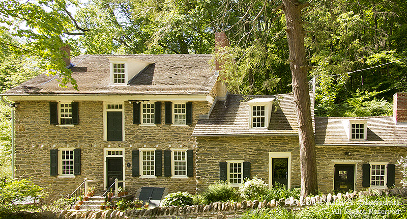 This is the Livezy House, built by a Quaker farmer and miller in 1749.
 Ah, Devil’s Pool. Cresheim Creek drains into the Wissahickon here in this deep green glen. Like many of the watery places along the creek, it is a popular, and illegal, swimming hole.
It’s also dangerous. Too many people are tempted to jump from rocks up to 20 feet high into a pool that is just 5 to 7 feet at its deepest. Drownings are not unheard of here. Frequently polluted water adds to the list of hazards.
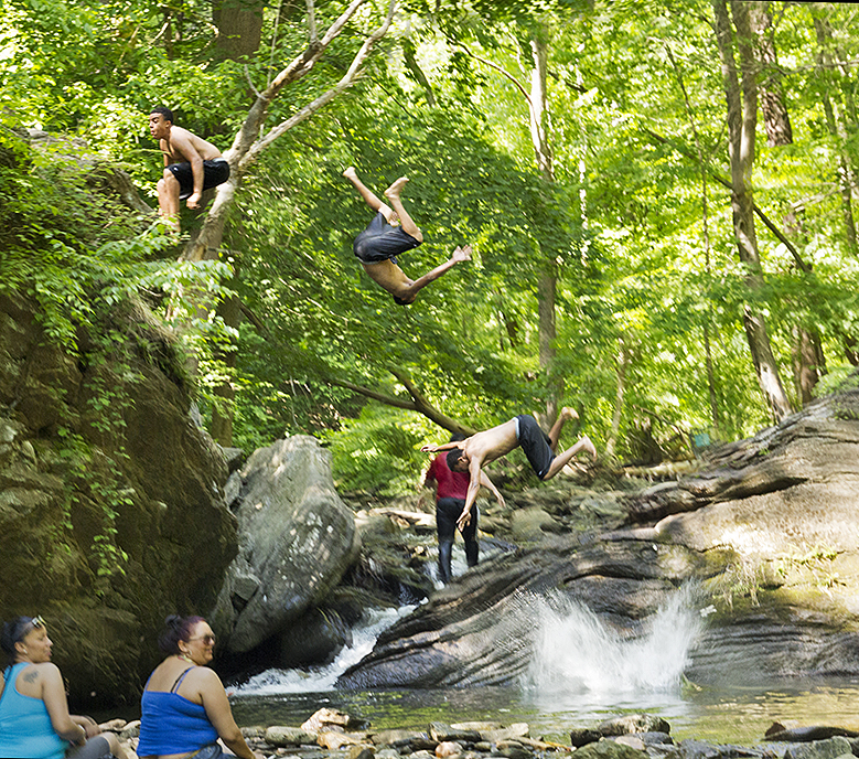 This time-lapse photo proves that young daredevils are not easily deterred by the risks. Here I blended four shots into one to capture all the action of a backward somersault into the pool.
 Like any urban area, Philadelphia is crowded, noisy, and paved-over. Yet within the city limits, in the Wissahickon Valley, Nature holds on as tenaciously as ferns cling to life in a rockface. Definitely urban living on the Wild Edge!
Presidents’ Day at Valley Forge
 Listen closely, the old tree said, and I will tell you of the birth of a nation.
 When I was but a young sapling, the rolling hills you see before you were dotted with farmsteads.
 Valley Creek flowed past iron forges before joining the Schuylkill River to the north.
 It was the winter of 1777, the heart of the American Revolution, when General George Washington decided my home provided everything he needed for a safe place to encamp his troops for the winter: easily defensible high ground, proximity to Philadelphia to pressure the British, the river nearby for transportation.
 I watched as 12,000 men marched into the valley on December 19, weary, bedraggled, but with their heads held high. They swiftly pitched tents as temporary shelter, then busily set about building log huts. They would complete nearly 2000 of these huts, chinked with clay and laid out along military avenues.
 The men then fell to building defensive fortifications: trenches, redoubts, and a bridge over the Schuylkill River.
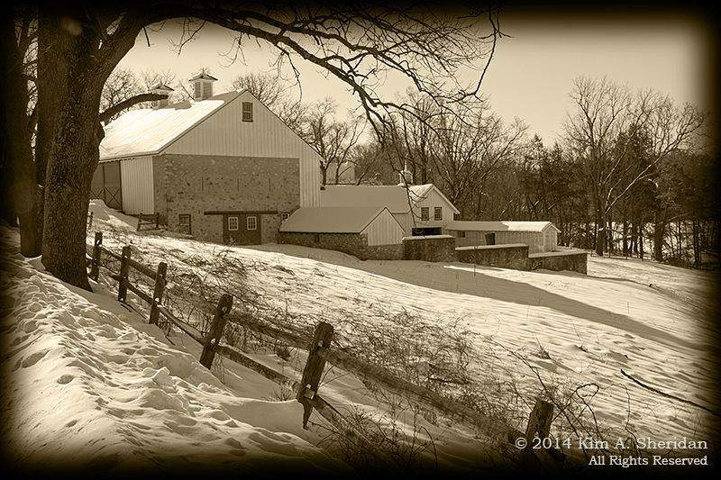
 Some of the officers made quarters in the houses of local farmers. It was more cramped than it may appear today. When General Henry Knox lived in the house above, it was half this size; expansion came after Revolutionary times. General James Varnum occupied only one room on the upper floor of this dwelling, below; the owner’s family continued to live in the rest of the house.
 Many of the officers, including Knox and Varnum, would later move into huts to be closer to their men.
 Washington himself had vowed to stay in his canvas tent until all the men were in huts, but the needs of command compelled him to move to larger quarters.
 I have seen many winters in my long life, some mild, some harsh. That winter at Valley Forge was neither. Typical of a Philadelphia winter, there were occasional snowstorms, followed by thawing, rain, and then refreezing. The resulting mud and ice interfered greatly with supply shipments. Heavy snow in February was followed immediately by heavy rain, and mud made roads impassable for a time.
 This was the real hardship the troops faced; not the weather, but the lack of supplies, particularly clothing adequate to the winter conditions. The lack of a true Quartermaster made the situation worse. Sanitation was also an issue. Springs and streams provided water, but were frequently fouled.
Relief arrived with better weather, an early shad run on the Schuylkill, and the appointment of General Nathanael Greene as Quartermaster.
 When they weren’t building, serving as sentries, or hunting for wood and food, they were engaged in military drill on the Grand Parade. In February, Baron Friedrich von Steuben arrived in camp, and was given the job of reforming the Army’s training and discipline. He began with the Commander-in-Chief’s Guards, and quickly won them over with his methods. The enthusiasm spread outward as ever large groups of men drilled and maneuvered skillfully. He also greatly improved the sanitation in camp.
 Far more soldiers died of disease than starvation or cold, and many of the deaths came in the warmer spring months.
 General Washington ordered the chinking removed from the huts to improve air circulation, and in early June abandoned the huts altogether, moving the entire Army across the Schuylkill River to tents.
 After France entered into an alliance with the United States, the British would abandon Philadelphia for New York. On June 19, 1778, Washington would lead the Continental Army out of the camp in pursuit. My valley returned to a place of peaceful farmsteads.
 Not a shot fired was fired at Valley Forge in battle. Yet the encampment marked a turning point in the war. France threw in its lot with the Americans. Conditions hardened the men. Von Steuben molded a skilled but inconsistently-trained army into a cohesive professional fighting force. Truly the Army that left Valley Forge was not the Army that arrived six months prior.
 In the passing years, I have seen the land consecrated by the men that followed, as first a state park in 1893 and then a National Park on July 4, 1776.
Many generations have come and gone. Yet I stand here still, my old limbs weary, honored to be a silent sentinel watching over the valley that forged a nation.
Sleeping Bear Dunes: Dune Culture
 What else is there to do on a warm and sunny day at Sleeping Bear Dunes National Lakeshore, after spending several hours on the Scenic Drive? Why, the Dune Climb, of course.
 The National Park Service would really prefer that visitors not climb just any dune in the park, due to their fragility and steepness. So the Service has set up this 150’ high dune where people can climb safely. And what a set up it is: There’s a huge parking lot, restrooms, a Park store, picnic tables and vending machines. All of which is smartly situated at the bottom of the dune. When you climb, you get the hard part over first, and then get the fun of running back down.
 Nearby a wooden beam shows the progress of the moving dune. It was placed here in 1985, and the edge of the dune is now sitting around 66’ in from the end; that means the dune is moving at a rate of 2.36’ a year.
I was a bit of a party pooper here, and didn’t climb the dune. I don’t really like going uphill in soft sand under a hot sun. Besides, the NPS vending machine ate my money without giving me a Klondike Bar, so I was cranky. I did go for a peaceful walk in the woods along part of the paved Sleeping Bear Heritage Trail. I also enjoyed reading the license plates in the parking lot. There were people that drove from as far away as Idaho and Vermont.
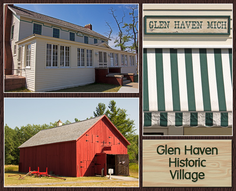 Glen Haven is a village restored to its heyday as a company town and port for steamboats. Sleeping Bearville, as it was once known, was active from 1865 on. Above, clockwise from top left: The Sleeping Bear Inn, which was built in 1857 and served guests until 1972. The awning of the Glen Haven General Store, as it appeared in the 1920s, when it was run by local lumber baron D. H. Day. The Blacksmith shop.
 David Henry (D.H.) Day ran the town of Glen Haven from the late 1800s to the 1930s. He financed and built houses for the workers, and was school superintendent. Above, clockwise from top left: The house Day built in 1890 for his wife – she preferred living over the store! The Glen Haven Canning Company, started in the 1920s by David Day Jr. after the collapse of the lumber industry, canned cherries, peaches and apples; today it houses a small fleet of old Lake Michigan boats. A house for a worker’s family. One of the boats on display in the Cannery.
 Sky, lake and the fishing boat Aloha.
In 1901, a United States Life Saving Service station was built on Sleeping Bear Point. It was much needed – there have been more than 50 shipwrecks in this vicinity. The Service became part of the U.S. Coast Guard in 1915. By 1931, the station had been nearly buried by sand, and the buildings were pulled, by horses, to their present location. The introduction of “unsinkable” 36’ motor boats, which could only be launched from harbors, made beachside stations like Sleeping Bear Point obsolete, and it closed for good in the early 1940s. Today it houses a museum showcasing crew life, the Life Saving Service and Great Lakes maritime history.
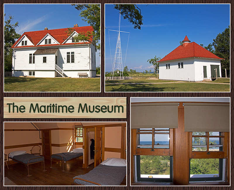 Above, clockwise from top left: the main crew quarters. The boat house. A view of the lake from an upstairs window. Part of the crew’s bunk room. The room housed seven men, who each had their own bed and small closet. Quite an austere existence for men who stood ready to risk their lives in the worst of conditions on a daily basis.
In the evening I drove around the Port Oneida Rural Historic District, a community northeast of Glen Haven that includes 16 historic farms. Several of the barn photographs that appeared in the earlier “Farm Country” post were taken here, including D.H. Day’s elaborate white barn. I wandered down a dirt and gravel road for a long time, and had to wonder why I did, after nearly getting stuck on a sandy hill. Then, when I reached a pull-out at the side of the road, it all became clear.
 Deep green trees, crystalline blue water: this is what I remember when I think of Michigan.
Coming up: Michigan’s Shy Wildlife
Back in Time: White Pine Village
 Okay, class, settle down and pay attention. Today’s lesson is history, and our field trip to Historic White Pine Village will give us a glimpse of life in 19th century Mason County, Michigan… Walk the paths and explore the buildings of a logging and farming community frozen in time. Let’s take a tour, shall we? Stay together, please!
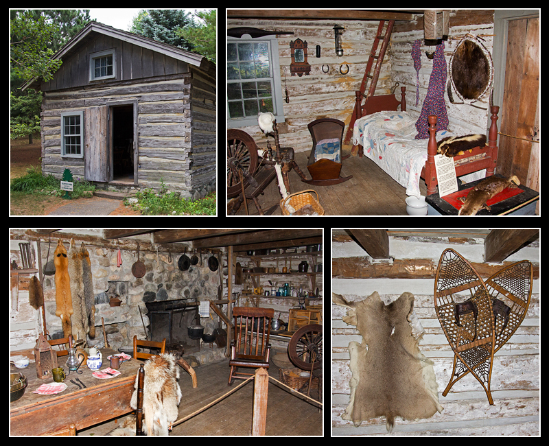 The first Europeans to arrive in Mason County, Michigan – around 1835, before it was Mason County – were the trappers. Foremost among them was William Quevillon, who built this log cabin in 1850. Five years later Quevillon was appointed postmaster, and this tiny cabin became the first authorized post office in Mason County, while still housing a family of six. Think your mail is slow and expensive? Postage on a letter to a nearby town was 50 cents, and mail was delivered just four times a year!
1847 saw the first permanent settlers. Burr Caswell, his wife and four children arrived by schooner. With no proper harbor at the time, the family’s livestock had to swim to shore. The coast was a dense wilderness of tall pine trees, wolves and other critters, and the closest settler was in Manistee, 30 miles away. Did I mention it snows 90” a year here? 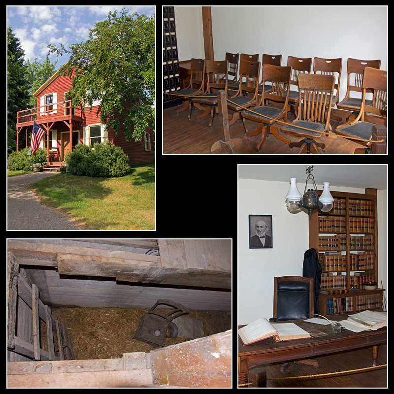 By 1855, there were enough settlers to form Mason County, and Caswell’s frame house did double duty as the county seat. With the family upstairs, the main floor became the courtroom. The jail was this comfy space in the basement. The county seat moved to Lincoln Village in 1861, and the Caswells got their home back.
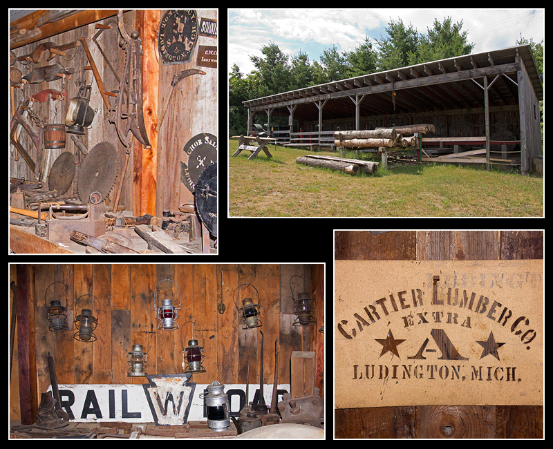 With all those tall pine trees, it was inevitable that lumbering would become the predominate industry in the area. The first mill was built on Pere Marquette Lake in the late 1840s. Other mills followed -14 on Pere Marquette Lake alone – and by the 1870s, business was booming. The sawmill shed pictured holds a 48’ portable sawmill that would have been moved from camp to camp. The railroad arrived around 1875. Competition was fierce among the lumber barons, but by 1910, the lumber industry was collapsing, as the timber supply had become completely depleted.
 In a lumbering community, fires were a constant threat, so fire departments were needed. Ludington’s first fire house was organized in 1883. The fire engine is a 1928 model.
 Farming was and continues to be very important in Mason County. In 1880, Thomas Burns Sr. paid $1,190 for 80 acres of land to raise apples, peaches, cherries, vegetables, chickens, cows and grain. Thomas and his wife Mary had nine children, all of whom were needed to keep the farm running. Cooking was done on a wood stove, washing on the back porch, and – ahem – other things in the outhouse. The tiny bedrooms are just barely bigger than the beds they house.
 The Burns family would have had a barn similar to this, built without nails. The windmill was used to pump water from the well. A typical farm would use many pieces of machinery, including plows, hay loaders, grain drills, wagons and corn binders.
 The Burns children would have attended a school – in the winter only – like the Marchido Schoolhouse, built around 1895. Imagine going to school every day here – kids of all ages together with one teacher, wood stove for heat, outside privy. Every child has a slate and desk, there’s a piano in one corner, and even a dunce cap. Better behave yourself!
 Every town needs a General Store. There are all kinds of items for sale here: soaps, spices, dishes, dry goods, barrels of flour and molasses, axes, pots, pens and paper, buttons, even saddles.
 The simple architecture of White Pine Chapel is typical of Protestant churches of the community.
If you’ve visited my Michigan gallery page, you will be familiar with Epworth Heights. To put the Methodist resort in historical perspective, it was founded in 1894, with the first cottages built the following year. Imagine – just 47 years after the arrival of the first permanent settlers, Mason County is popular enough to have its own resort!

White Pine logs, Michigan, ca. 1910
CONSERVATION PIECE: Commercial logging in Western Michigan in the late 1800s had a devastating effect on the environment. Wide scale clearcutting left a landscape of stumps and woody debris; erosion was widespread, and fires frequently broke out. Furthermore, these areas were intentionally burned to provide farmland, which they were ill-suited for.
Fortunately, wiser minds began to see the danger, even while the destruction was going on. In 1887, the Forestry Commission was formed to protect and restore the state’s forests, three years before lumber production would reach its peak. In 1900, state reserves were created for reforestation. In 1938, Manistee National Forest was formed; it now encompasses 540,187 acres, including portions of Mason County.
Today, a large part of the logged areas have been reforested, with white and pine forests replaced by aspen, birch, oak and jack pine. The production of wood and forest products continues, albeit with an emphasis on sustainability and preserving the health and diversity of habitat and waterways. Particular care is taken to protect threatened species such as the Kirtland’s Warbler, Piping Plover, Karner Blue Butterfly and Pitcher’s Thistle. In addition, a wide range of recreational opportunities exist within the forest.
In other words, Michigan’s forests may not be pristine, but they’re a darn sight better than they were in 1890, and the days of uncontrolled clearcutting are long gone.
I hope you’ve paid attention, class. There will be a pop quiz tomorrow…
Coming soon: Farm Country
Independence Day I: Wissahickon Wanderings
or
What I Did On The Fourth of July
 This year ranked as one of my more unusual Independence Day holidays. Several Refuge friends and I went exploring in Fairmount Park and then the Morris Arboretum.
Fairmount Park in Philadelphia is the one of the largest urban park systems in the US, and spreads throughout much of the city. The 1800 acre portion along the Wissahickon Creek, known as the Wissahickon Valley, is actually a gorge, with the wooded slopes rising nearly 200 feet above the Creek. It’s as close to wilderness as one could be in a big city.
Our primary goal here was to see the Thomas Mill Road Covered Bridge. To reach it we took a long, easy walk down Forbidden Drive.
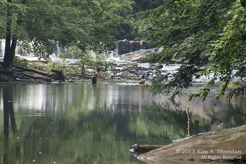 Kids swimming in the Creek. It was hot and humid, and later in the day I really wanted to join them.
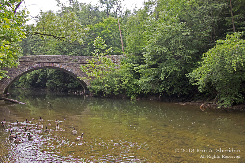
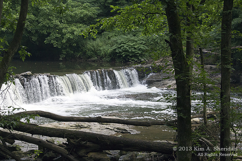 One of the remnant dams along the Creek. The dams supplied water to run the waterwheels of the lumber, paper, and grist mills that once populated the Valley.
 “Oh look – lunch!”
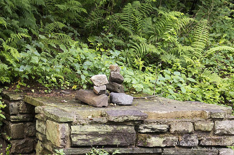 Trail art, by humans.
 I spent some time trying to persuade at least one Eastern Tiger Swallowtail butterfly to be still long enough for a picture. Didn’t have much luck.
 More trail art. Courtesy of Mother Nature this time.
When you walk anywhere with the botanically-inclined, you can expect frequent discussions on the identity of this or that plant. Here’s Robb (in orange) and Jeff arguing, ahem, discussing the identification of a tree.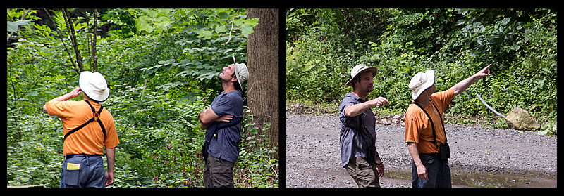 “This tree over here?” “No! THAT tree over THERE!”
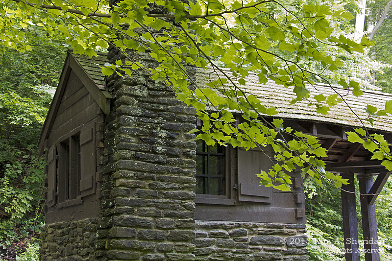 Really cool old building, originally part of a nearby mill, but rebuilt by the Works Projects Administration (WPA) in 1938. They were used to shelter the Fairmount Park Guards who once patrolled the park.
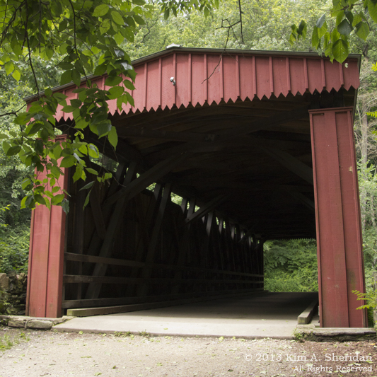
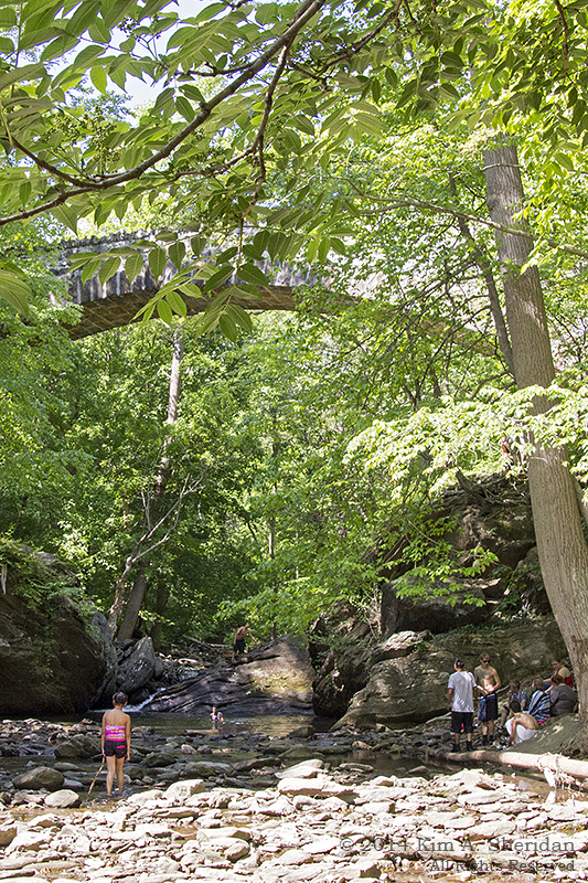
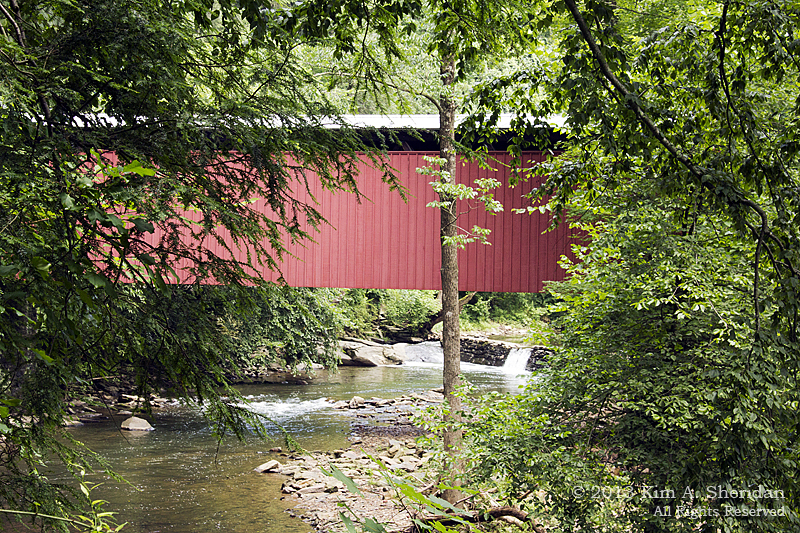
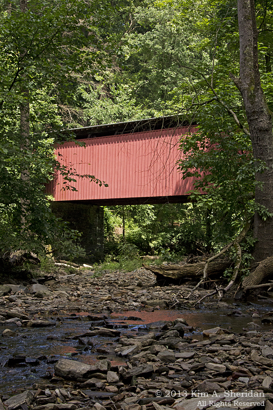 Ahhh! At last! The Thomas Mill Road Covered Bridge.
It was built in 1737, and restored by WPA in 1938. It’s the last covered bridge in the Valley, and the only covered bridge in a major U.S. city.
There’s something picturesque about a covered bridge. I think it’s the play of red against the green foliage.
Aren’t all covered bridges red?
Here’s Don, looking every bit the bold explorer, in front of the bridge.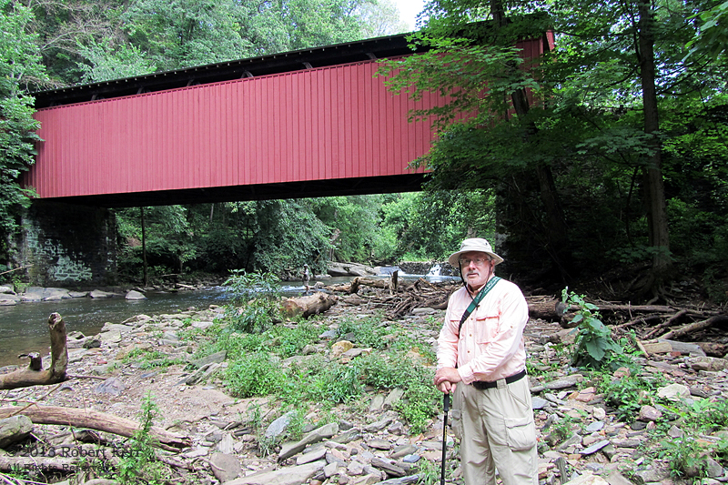
We crossed over the Creek here, and came back to Valley Green via the trail. A totally different walk. Where the Forbidden Drive was wide, the trail was narrow; where it was flat, the trail climbed sharply up and down; where the Drive was crowded with bikers and runners and horses, the trail was – well, not empty, but certainly less crowded.
Our goal along the trail side of the Wissahickon was “The Indian”. The Valley was once the home of the Lenni-Lenape people. In 1902, after they were long gone, a 15 foot high sculpture was erected in their honor. It depicts a Lenni-Lenape warrior, kneeling and shading his brow as he watches his tribe depart from the region. Of course, the artist couldn’t be bothered to differentiate among the traditions of the various Native American nations that lived here. Which is why an Eastern Woodland Indian is wearing a Western Plains Indian headdress.
On the Forbidden Drive side we’d come upon a sign marking the Indian statue, placed high up on the far bank of the creek. The only trouble was, we couldn’t see the statue for the trees.
With the help of some other trekkers, we found the pathway to the Indian.This was a short but tough trail that went straight up; you get some idea of the steepness of the Gorge from this set of stairs. We found ourselves below the base of the statue. This was a great view, and I wanted a great shot, but as you can see but I blew the focus. Oh, well, I will just have to go back.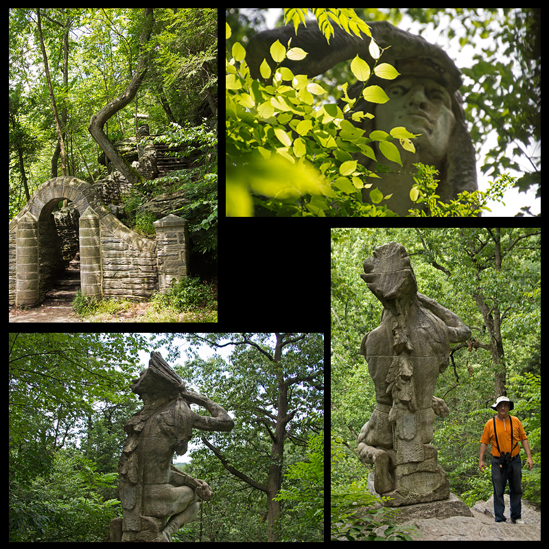 Up at the top we got a perspective I am quite familiar with from my wildlife photography – the rear end. Here you can see that the statue is slightly more than two Robbs high. And since the Indian’s kneeling – well, that’s one big Indian.
Leaving our friend, we discovered a much easier path back down to where the main trail awaited. Wish we’d known that before! From here back to the car, the trail got tougher, as we needed to clamber over roots, tree trunks, rocks and even small streams. A couple of times I found it easier to slide on my bum. Eventually we made it back to Valley Green, where another adventure awaited – finding a restaurant that was open on the Fourth of July.
 My dad grew up very close to the Wissahickon Valley in the 1930s and ’40s, and spent a lot of time there. And told me a lot of tall tales from his boyhood. This first visit just made me more determined to see more of the area he knew so well.
Coming up: Independence Day II: A Morris Mosaic
Photo of Don courtesy of Robb Kerr
Historical information courtesy of the Friends of the Wissahickon http://www.fow.org/about-park
